 Image 1 of 4
 Image 2 of 4
 Image 3 of 4
 Image 4 of 4
High Peak in Derbyshire includes Buxton, Glossop, and Chapel-en-le-Frith. Famous for its Peak District fringes, historic towns, and natural landscapes, about 7.4% of the district is Green Belt. Planning balances rural conservation with residential and commercial development. We can advise and support projects across High Peak.
In the last year High Peak decided 354 applications which is well below the national average of 988. The approval rate was 86% (roughly equal to the national average of 88%) and 27% of applications were decided on time, (significantly below the national average of 59%). Stats updated March 2026 from gov. sources. See how High Peak performs relative to other LPAs in our LPA hub.
High Peak has a sensitive historic environment shaped by its upland landscape and dispersed settlements, with several Conservation Areas and numerous listed buildings. Heritage constraints are particularly evident within the Buxton Conservation Area and Hayfield Conservation Area, where historic townscape, Millstone Grit stone, and topography define local character. Development proposals are assessed in relation to these assets and their wider setting.
One of the top reasons heritage building applications are refused is causing harm to historic significance, a risk that can arise when proposals are not prepared by a consultant with heritage expertise. We help minimise this risk with expert, site-specific guidance; contact us here.
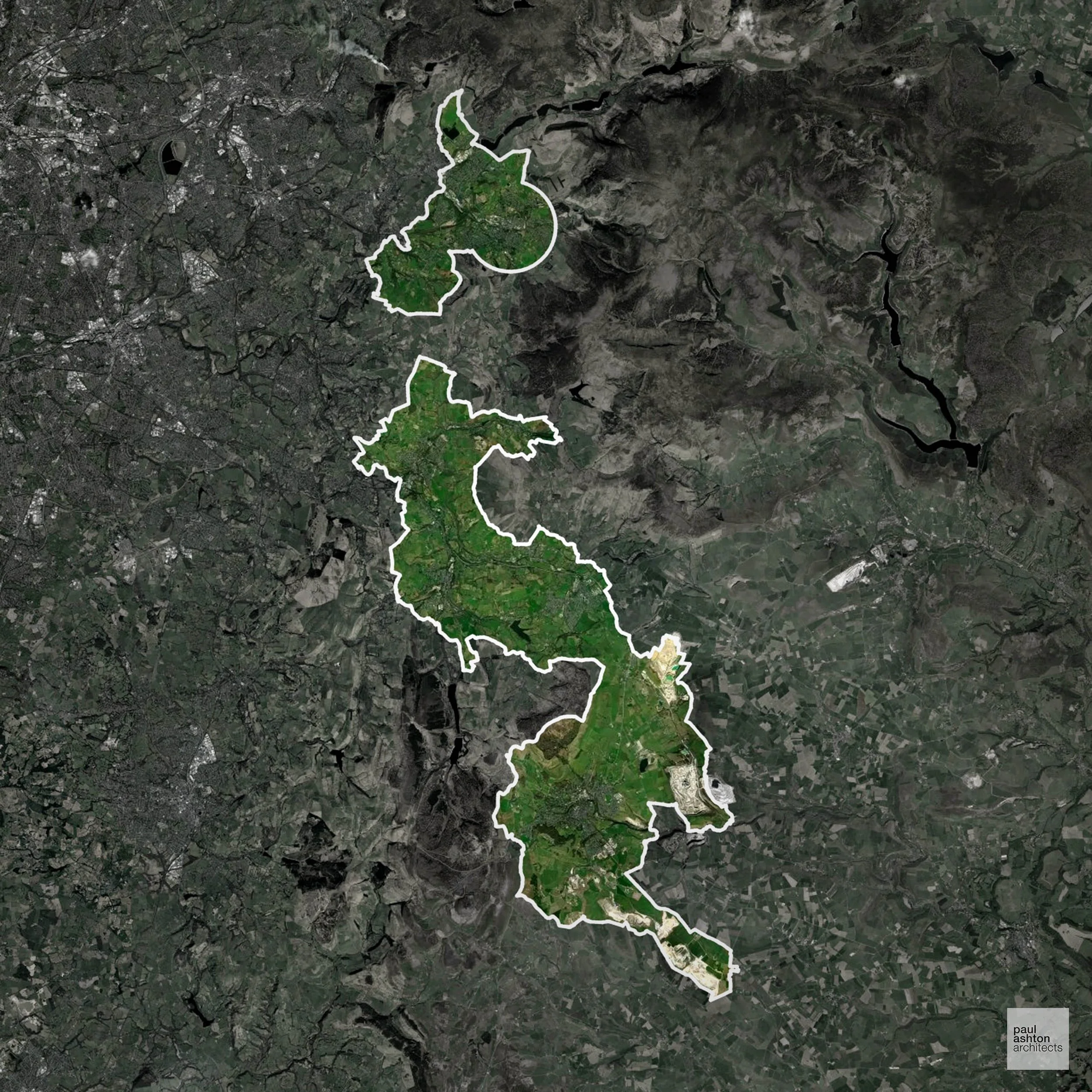
7.4% of High Peak is within the Green Belt and proposals in these areas can be subject to reasonable levels of scrutiny.
The High Peak Green Belt is fairly minimal in extent but it protects the rural Pennine foothills, moorland edges, and villages such as Glossop and Chapel-en-le-Frith, preventing coalescence and safeguarding sensitive upland landscapes.
In our experience, one of the top reasons poorly conceived Green Belt proposals are refused is causing 'harm to openness'. We can lower the risk of refusal with site-specific guidance. Contact us here.
You can also check whether your land is within the Green Belt using our interactive Green Belt map.
High Peak features parts of the Peak District National Park and Dark Peak moorlands, where open upland landscapes are protected for their visual and ecological importance.
One of the top reasons poorly prepared proposals in the Open Countryside are refused is that they fail to demonstrate a policy-supported need. To minimise that risk with bespoke advice contact us here.
Parts of High Peak, and perhaps most significantly Buxton, fall within the Peak District Dales SAC catchment, where phosphorus neutrality is required for residential development in the affected area.
Unfortunately, Nutrient Neutrality can halt development completely. If you need early-stage, project-specific advice contact us here.
Alongside acting as Planning Consultants we are ARB registered architects with 25+ years of experience. We advise on and prepare planning applications across a range of development types, including:
We specialise in resolving complex planning challenges through thoughtful architectural design, turning constrained or difficult sites into successful Planning Permission outcomes. Let’s discuss your project.
High Peak in Derbyshire includes Buxton, Glossop, and Chapel-en-le-Frith. Famous for its Peak District fringes, historic towns, and natural landscapes, about 7.4% of the district is Green Belt. Planning balances rural conservation with residential and commercial development. We can advise and support projects across High Peak.
In the last year High Peak decided 354 applications which is well below the national average of 988. The approval rate was 86% (roughly equal to the national average of 88%) and 27% of applications were decided on time, (significantly below the national average of 59%). Stats updated March 2026 from gov. sources. See how High Peak performs relative to other LPAs in our LPA hub.
High Peak has a sensitive historic environment shaped by its upland landscape and dispersed settlements, with several Conservation Areas and numerous listed buildings. Heritage constraints are particularly evident within the Buxton Conservation Area and Hayfield Conservation Area, where historic townscape, Millstone Grit stone, and topography define local character. Development proposals are assessed in relation to these assets and their wider setting.
One of the top reasons heritage building applications are refused is causing harm to historic significance, a risk that can arise when proposals are not prepared by a consultant with heritage expertise. We help minimise this risk with expert, site-specific guidance; contact us here.
7.4% of High Peak is within the Green Belt and proposals in these areas can be subject to reasonable levels of scrutiny.
The High Peak Green Belt is fairly minimal in extent but it protects the rural Pennine foothills, moorland edges, and villages such as Glossop and Chapel-en-le-Frith, preventing coalescence and safeguarding sensitive upland landscapes.
In our experience, one of the top reasons poorly conceived Green Belt proposals are refused is causing 'harm to openness'. We can lower the risk of refusal with site-specific guidance. Contact us here.
You can also check whether your land is within the Green Belt using our interactive Green Belt map.
High Peak features parts of the Peak District National Park and Dark Peak moorlands, where open upland landscapes are protected for their visual and ecological importance.
One of the top reasons poorly prepared proposals in the Open Countryside are refused is that they fail to demonstrate a policy-supported need. To minimise that risk with bespoke advice contact us here.
Parts of High Peak, and perhaps most significantly Buxton, fall within the Peak District Dales SAC catchment, where phosphorus neutrality is required for residential development in the affected area.
Unfortunately, Nutrient Neutrality can halt development completely. If you need early-stage, project-specific advice contact us here.
Alongside acting as Planning Consultants we are ARB registered architects with 25+ years of experience. We advise on and prepare planning applications across a range of development types, including:
We specialise in resolving complex planning challenges through thoughtful architectural design, turning constrained or difficult sites into successful Planning Permission outcomes. Let’s discuss your project.